
The Alexandria Digital Library (ADL), in conjunction with the Map and Imagery Laboratory (MIL) in the Davidson Library at the University of California at Santa Barbara, offer the following collections and related services to the D-Lib Test Suite for digital libraries research.
ADL and MIL are in the process of forming significant collections of georeferenced information: information that is relevant to particular regions of the Earth's surface and that has associated with it latitude/longitude coordinates. The collections are being formed by ingesting existing data sets where possible, but some original data sets are being created as well. The goals of the collections are twofold: to support research into digital library architectures, and to serve as the basis of an operational digital library supporting the Earth and social sciences.
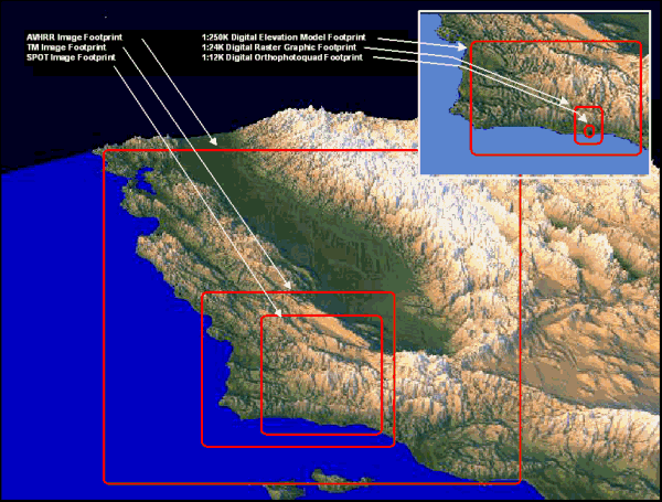
The ADL collections are focused predominantly on Southern California, but there is some worldwide coverage. The collections emphasize coverage of targeted areas at a wide range of resolutions and extents, from the low resolution and wide extent of remote-sensing images to the high resolution and narrow extent of digital orthophotos. The following diagram illustrates the range of extents provided by ADL collections.
The ADL collections are heterogeneous in nature and content, but they can be uniformly accessed via both JIGI (ADL's graphical Java client) and a programmatic HTTP interface. See the JIGI Home Page for more information.
The collections described briefly below are more fully described and characterized by their ADL collection-level metadata, which includes both descriptive information (scope, purpose, content type, etc.) and overviews (numbers and types of items, spatial and temporal coverages, etc.). Interested readers are encouraged to visit the ADL Collection Metadata Index. The ADL Collection Metadata Content Standard, an XML Document Type Definition, formally defines the semantics of the collection-level metadata.
The ADL Catalog is ADL's principal, union-type collection. It contains geospatial and georeferenced data of many types (maps, aerial photographs, remote-sensing images, scientific data sets, text documents, etc.) and formats (images, GIS layers, offline paper documents, etc.). Some of the major series included in this collection are:
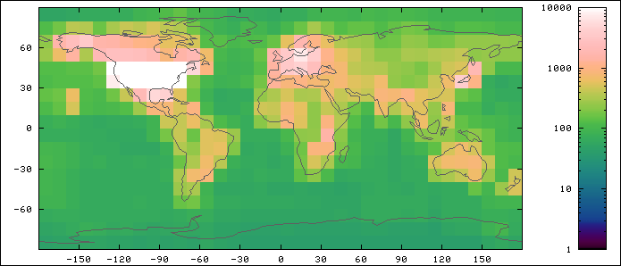
The ADL Catalog is dynamic and is continually being added to. At the time of writing, it contains 330,000 items, with another 600,000 items awaiting loading. The spatial coverage of the ADL Catalog is shown graphically in the tiled map below. Each tile represents a 10° × 10° area of the Earth's surface. The color of a tile reflects the number of items that overlap that tile; the lighter the color, the more items that overlap. The legend to the right of the map shows the correspondence between color and number of items.
A gazetteer is a set of geographic names (place names and feature names) joined with their latitude/longitude locations and other descriptive information. A gazetteer can be used to find the location of a geographic name, and conversely can be used to find all geographic names within an area. These searches can be restricted to particular types of features, for example, to just hydrographic features, or more specifically, to just lakes.
The ADL Gazetteer contains 6 million names, and combines the U.S. names from the U.S. Geological Survey's Geographic Names Information System (GNIS) and the non-U.S. names from the National Imagery and Mapping Agency's GEOnet Names Server (GNS). Note that all these names are associated with point locations only.
A new version of the ADL Gazetteer, to be released in early 1999, will include richer geographic descriptions for some names (e.g., bounding boxes and/or polygonal outlines for countries and U.S. states and counties) and will be based on a new and richer metadata content standard.
GeoRef, a service of the American Geological Institute (AGI), is a bibliographic database containing more than 2 million references to geoscience literature. The ADL GeoRef collection is the subset of the full GeoRef database restricted to the state of California. All items in this collection are MARC records referring to hardcopy journal articles, conference papers, government reports, etc.
The Institute for Crustal Studies (ICS) Earthquake collection covers California earthquake history, including Baja California and Nevada earthquakes, from 1769 to present. The data for an earthquake includes its name, time, magnitude, etc.; for selected earthquakes, links to web pages with more specific information are provided.
This collection will be merged with the new ADL Gazetteer in early 1999.
The ICS Volcano collection contains basic geographic and geologic information for 1,500 volcanoes thought to have been active in the last 10,000 years (Holocene era). The data for a volcano includes its number in the Catalog of Active Volcanoes of the World (CAVW); the volcano's name, location, summit elevation, volcano type, and status; and the time range of the last recorded eruption.
This collection will be merged with the new ADL Gazetteer in early 1999.
ADL maintains a database of registered users, and logs users' sessions with the system for evaluation purposes. The registration data for a user includes a small set of user-supplied characteristics that can be linked to patterns of system use captured in the session logs. User characteristics include:
The information logged during a session includes the actions the user performed within JIGI (almost to the specificity of individual mouse-clicks) as well as the queries the user submitted to the system, the collection items downloaded, and so forth. Session log data is maintained in textual form in files and/or databases.
For general information about the Alexandria Digital Library, see the web site:
http://www.alexandria.ucsb.edu/.
Researchers with serious interests in using the testbed, should contact: Greg Janée, [email protected].
The contact for all user- and evaluation-related data is Linda Hill.
Evaluators wishing to use the ADL session logs and/or user registration database should first consult the Policy on Permitting/Supporting Evaluation Studies of the Alexandria Digital Library. ADL is particularly concerned with maintaining the privacy of its users. Access to the user registration database requires special permission. Session logs are linked to the user registration database through opaque user identification numbers, and thus access to session data is granted more freely.